It may just be that from a business perspective in the information age, misinformation is more appreciated than no information at all. Especially given how quickly 'facts' change. JL
John Homenuk comments in Medium:
Understand that more than ever, individuals, and sometimes even news outlets, will be
posting these things for reasons other than just to warn you of
impending bad weather. Always remember that forecast models beyond 5–7
days are subject to extreme variability, and are unreliable — *especially*
snowfall totals.
The breaking point may have been during the middle of Winter 2014–2015. It took me until today, a late Autumn day in 2015, to fully gather all of my thoughts, to the point where they could be articulated in an understandable fashion.
Around 6:30am, on a freezing cold night late in January of 2015, our company received an inquiry regarding the potential for a winter weather event in 7 days. This is nothing terribly unusual; our email inbox is filled with these during the winter months. We do our best to try and answer them all, while keeping readers as informed as possible. The title of the email read “Information Regarding Blizzard Feb 8”, and the body of the message asked us for our snowfall forecast for the upcoming “blizzard”, which the user was under the assumption was going to arrive next week.
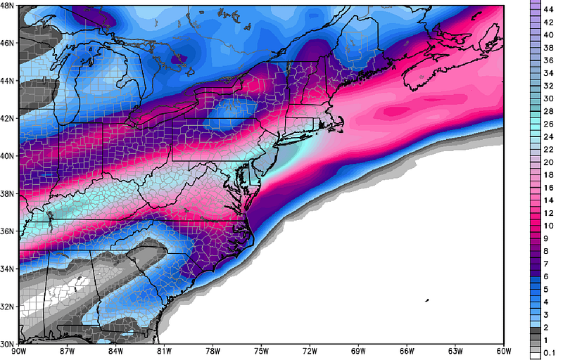
Embedded in the email was a model image, produced by Weatherbell Analytics, which showed the snowfall totals from an ECMWF Ensemble Control run (we’ll explain these later) at 216 hours. This was the moment I realized that meteorologists had a big problem on our hands.
The principle behind this email, and broader problem, is nobody’s fault. Not the mailer, nor the company which produced the map. It isn’t our fault, your fault, or any meteorologists fault. In fact, nobody is to blame at all. But it is a problem, because the image went viral on social media and many in the general public took it as a fact.
And so, as meteorologists, it is our job to source back to the larger issue and try to figure out how to avoid a recurrence. Similar things have occurred during storms in the past, and it seems with each passing season the frequency increases.
In the meteorological community, the root of the issue lies in this simple fact:
People want to share information as quickly as possible to reach as many people as they can.
Some have no ill intentions and want to share the information for the greater good. Others specifically tailor their posts to try and share model images that garner attention and hype. Regardless, the images are making it all over the internet.
Think of it this way: Weatherbell produces these model images for meteorologists, forecasters and hobbyists. There are 50 other sources (probably more) from which you can gain this information as well. In today’s technological age, these images make their way into the hands of thousands — and not everybody, like meteorologists, can understand the exact significance of them.
Here is the model image, via WeatherBell Analytics, that was sent to us in an email. The image shows snowfall totals from the ECMWF model’s ensemble member, valid 200+ hours in advance.
And the issue, therefore, lies within the “understanding gap” between the public and meteorologists.
Here’s something which my freshman year meteorology professor made very clear was essential while working in the field: Forecast models are for guidance only.
This seems like a simple piece of advice at first, but it has come up time and time again in my experience forecasting over the last 6+ years. It is essential to remember that forecast models are computers, which are simulating the fluid atmospheric process. There are many forecast models, all with a different set of equations, resolution, and biases.
As meteorologists, our job is to understand the actual evolution and progression of the pattern and discern between which models have the correct idea and which don’t. As you can imagine, beyond about 84 hours in advance, it can become a total mess. So when we see these images of a random forecast model’s snowfall forecast at 200+ hours going viral, we cringe.
The thing is, it isn’t the general public’s job to understand this.
So this leaves us meteorologists with two goals. First, we shouldn’t share information that won’t do the public any good. There is a fine line between creating fair warning and causing confusion and hype. We need to continue to differentiate between what is relevant and what isn’t. Second, we need to educate our readers, to the best of our ability, on what these forecast models mean and what the images are telling us. This will help bridge the gap in understanding between meteorologists and the general public, eventually causing less hype and confusion.
Medium and long range forecasting, anywhere beyond 84 hours in advance, is much more about meteorological pattern recognition than it is about individual forecast models. The model image pictured above was one solution among an innumerable amount. To speak to its variability, that very same forecast model showed absolutely no snow the next time it was run, 6 hours later.
Meteorologists, for instance, use ensemble guidance at this range to help cut down on the wild variability. Many global forecast models have an ensemble of “satellite models” (a handful of similar models running sometimes at lower resolution). Meteorologists can analyze these individual ensemble solutions, and sometimes take a mean of them all, to gain a better understanding of the pattern evolution and analyze trends over time.
Here’s my advice: Use your trusted sources. Understand that more than ever, meteorology information is becoming freely available. Individuals, and sometimes even news outlets, will be posting these things for reasons other than just to warn you of impending bad weather. Always remember that forecast models beyond 5–7 days are subject to extreme variability, and are unreliable — they simply are not designed to be used for individual forecasts *especially* snowfall totals.
Most importantly try to differentiate between what meteorologists flag as potential, through their understanding of the pattern, and what others may be flagging as potential to build hype, views, or “likes”.
Meteorology is a very complicated field. This is something that probably has become increasingly evident to many people over the past several years, regardless of prior opinions. It truly is a unique and difficult science. That being said, the general public has come to a much better understanding of how the innards of the forecasting process work — and we can still improve that understanding.
With meteorologists and the public working together to understand each other, we can significantly cut down on the amount of miscommunications and misunderstandings we have in the future.
As a Partner and Co-Founder of Predictiv and PredictivAsia, Jon specializes in management performance and organizational effectiveness for both domestic and international clients. He is an editor and author whose works include Invisible Advantage: How Intangilbles are Driving Business Performance. Learn more...


0 comments:
Post a Comment