The Battle To Become the Google Maps For Self-Driving Cars
Won't Google Maps be the Google Maps of self-driving cars? Maybe not.
Because this type of mapping is very different from the kind that lets you know where the nearest Starbucks is. Plus, lots of companies dont want Google having that power, especially given that it is a competitor in the autonomous vehicle business itself. JL
Elizabeth Woyke reports in MIT Technology Review:
Though companies are testing autonomous vehicles in just a few cities now, trials will
expand to dozens of cities and span thousands of miles within the next
year or two. “These machine maps haven’t been built on a large scale
yet.” “If you’re programming a car to turn a corner, you need to know where
you’re located within the map, not where
you are in the world in an absolute sense. With
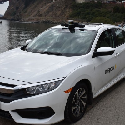
this new type of map, you get localization baked in, which is important because GPS alone isn’t stable or predictable enough.” Self-driving cars navigate using both onboard sensors that spot obstacles and detailed, 3-D maps of streets, signs, and infrastructure. But building these maps, and keeping them up to date, is a huge undertaking. Mapper.ai, a San Francisco–based startup, wants to make the process simpler with a service that provides continuously updated maps on demand.
The service lets companies select any place in the world they want mapped, provided it has public roads. Mapper then hires local drivers to collect geographic data, converts the data into 3-D maps, and sells the maps—and subsequent updates—via a subscription service.Mapper has been working with a small group of customers for the past year on maps for autonomous or semi-autonomous driving. The company currently has maps of places in Asia, Europe, and North America, and its eventual goal is to assemble the world’s largest repository of up-to-date, machine-readable maps of city streets and freeways. Though companies are testing autonomous vehicles in just a few cities right now, Mapper CEO and cofounder Nikhil Naikal thinks trials will expand to dozens of cities and span thousands of miles within the next year or two. “These machine maps haven’t been built on a large scale yet,” says Naikal, who has worked on autonomous-vehicle sensors and mapping for more than a decade. “We’re on a mission to create them all over the world, faster than anyone else—and because we own them, we can sell them to everyone.”Mapper credits its broad reach and speed to its network of freelancers. Most of its drivers also drive for ride-sharing services like Uber or Lyft; they capture mapping data in the middle of the day, when few people request rides. (Mapper lures them by paying rates as high as $3 per mile, triple the $1 per mile the average Uber driver is believed to earn.)
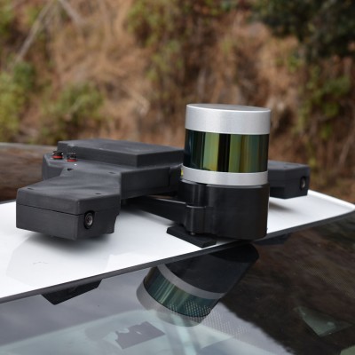
The drivers use their own cars, and Mapper provides the mapping devices, which cost about $350 to build. Instead of designing pricey, proprietary hardware, the startup buys sensors off the Chinese e-commerce site Alibaba and adds its own software that fuses all the data together. One device model, which wraps around a car’s rear-view mirror, has four machine-vision cameras and sensors that measure linear and angular motion. Another sits on top of a car’s roof and consists of two machine-vision cameras, motion sensors, and a simple lidar. Drivers use that device to map dense city streets, because lidar is good at capturing the geometry of three-dimensional structures. The company claims its approach captures details that are accurate within five centimeters , which is on par with other technologies.
To map an area, drivers simply follow turn-by-turn audio directions that Mapper pipes through a mobile app synched to the mapping device. Once the drivers finish their assigned tasks, they upload the information to Mapper’s cloud storage facility, where it is converted automatically to what’s known as a point cloud, a 3-D representation of the world. A second team of freelancers looks at the data and adds notes about lane markings, traffic signs, and stoplights. Mapper delivers the finished maps to customers over Wi-Fi, typically 24 hours after it receives the driving data. Mapper has designed two devices that freelance drivers can use to map their surroundings. This model attaches to the car roof magnetically and includes machine-vision cameras, an accelerometer, a gyroscope, and a low-cost lidar.
Courtesy of Mapper
This distributed workforce and self-serve model enable Mapper to offer its customers updates as often as daily while guaranteeing that its maps will cover 100% of a given area. “Once we have a driver on the ground, we can do that routing as frequently as customers want,” says Neehar Garg, who leads Mapper’s product development. “Updates get easier and easier, because we only have to spend time on the things that have changed in an environment.”
A Mapper customer, who asked not to be named because he works for an automaker that is using the maps in a secret project, says he hired the startup over bigger names like HERE and TomTom. “If you’re programming a car to turn a corner, you need to know where you’re located within the map you’re using [for navigation], not where you are in the world in an absolute sense,” says the customer. “With this new type of map, you get that localization baked in, which is really important because GPS alone isn’t stable or predictable enough.”
Other startups in this industry, such as DeepMap, also make localized maps, but they ask their customers to gather the information for them. Because those companies don’t own their own mapping data, they tend to build individual maps of the same area for each customer. Naikal says that approach won’t scale once autonomous vehicles move from development to production and deployment. It makes no sense to create a map of, say, Market Street in San Francisco 20 times for 20 different customers when you can sell a single map to multiple customers and ensure it is always current, he says.
While self-driving cars haven’t yet delivered on their promise to revolutionize transportation, Naikal hopes his cartography collection can become the basis for innovation. He’s even thinking of providing maps to individual developers and engineers, similar to the way mobile-app developers use location information from Google Maps (although he hasn’t decided whether Mapper will charge for access). “Today it’s not possible for five developers to hang out in Starbucks and create an autonomous-vehicle solution,” says Naikal. “But it could be if we remove barriers and let people request and get [machine-readable] maps of any area.”
As a Partner and Co-Founder of Predictiv and PredictivAsia, Jon specializes in management performance and organizational effectiveness for both domestic and international clients. He is an editor and author whose works include Invisible Advantage: How Intangilbles are Driving Business Performance. Learn more...


0 comments:
Post a Comment