Lyft Will Give Directions To Scooters, Public Transit As Uber Overlays Congestion
The data on added Lyft and Uber generation congestion are damning, so the ride hail companies are responding. The question is whether consumers will avail themselves of the added options. JL
Alissa Walker reports in Curbed, Josh Constine reports in Tech Crunch:
For each mile of personal driving Uber and Lyft eliminated, they added
2.8 miles of professional driving — for an 180% increase in total
traffic.Adding transit and scooters is part of Lyft’s mission to take 1 million cars off the road by the end of 2019. Seeing traffic conditions could help users choose when it’s time to take
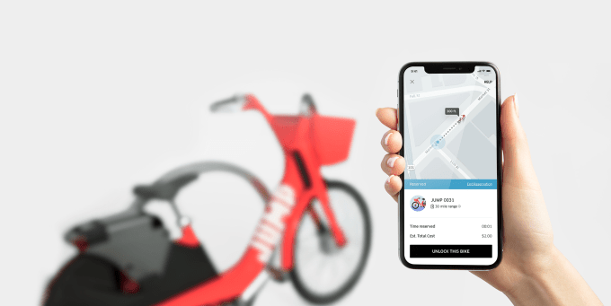
one of Uber’s non-car choices. They could sail past traffic on one of Uber’s new electric JUMP Bikes, or buy a public transportation ticket from inside Uber Curbed
As Lyft launches e-scooters and e-bikes in Santa Monica, the ride-hailing company is debuting an app update to help residents find its dockless vehicles—and connect to public transit.
Users in Santa Monica who have updated the Lyft app will see a feature where they can view nearby transit routes with real-time arrival information, as well as the distance to the nearest Lyft scooters.
Instead of routing a car to the user’s location, typing in a destination will allow users to switch between modes, and provide walking or riding directions to the nearest scooter or transit stop.
Now the ride-hailing company is providing data and access to vehicles that can make it easier for its users to avoid cars altogether.
Attendees of the Global Climate Action Summit in San Francisco got a brief peek at the update at a University of California at Davis’s transportation event. Lyft’s autonomous vehicle strategy director Lia Theodosiou-Pisanelli showed screengrabs of how the multimodal function would work as part of a panel on achieving the country’s climate goals.
Adding transit and scooters is part of Lyft’s mission to take 1 million cars off the road by the end of 2019, according to a blog post by Lyft co-founder John Zimmer. Recently the company announced that it was offsetting all its emissions with renewable energy in an effort to go completely carbon-neutral.
Santa Monica will be the first city to debut Lyft’s e-bikes and the second city to debut Lyft’s scooters, which launched in Denver earlier this month. Both will be direct competitors to Uber’s Jump e-bikes, which are currently found in several cities, and Jump scooters, which the rival ride-hailing company will be debuting in Santa Monica for the first time.
Many trip-planning apps are providing more multimodal information. Uber recently redesigned its app with an option to toggle to “bike” to locate Jump bikes in areas where bikes are found and will add transit and rental car information as well.
Trip-planning apps Transit and Citymapper, which already integrate public transit, ride-hailing, and walking directions, have recently added the ability to locate bike and scooter rentals.
A Lyft spokesperson said the company will share more details on the transit integration Wednesday. Lyft’s proposal for Santa Monica’s pilot program included examples of what the app’s e-bike directions with local transit might look like.
Lyft is partnered closely with Santa Monica on several other transportation initiatives. Right now, Lyft provides $3 late-night rides from Expo Line stations from 8 p.m. to 3 a.m. and the city is mulling replacing three low-ridership Big Blue Bus lines with subsidized Lyft rides as well.
Like other participants in Santa Monica’s pilot, Lyft has committed to investing $1 per scooter per day to fund biking and walking infrastructure.
The city hosted an event Monday morning with all four micromobility partners to launch the program and give residents what will be the first rides on some of the new vehicles. Tech Crunch
If the whole map is red and it’s a short ride, maybe you’d prefer taking an Uber JUMP Bike instead of an UberX. Or at least if you do end up stuck bumper-to-bumper, the warning could make you less likely to get mad mid-ride and take it out on the driver’s rating.
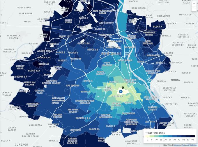
TechCrunch spotted Uber overlaying blue, yellow and red traffic condition bars on your route map before you hail. Responding to TechCrunch’s inquiry, Uber confirmed that traffic estimates have been quietly testing for riders on Android over the past few months and the pilot program recently expanded to a subset of iOS users. It’s already live for all drivers.
The congestion indicators are based on Uber’s own traffic information pulled from its historic trip data about 10 billion rides plus real-time data from its drivers’ phones, rather than estimates from Google that already power Uber’s maps.
If traffic estimates do roll out, they could make users more tolerant of longer ETAs and less likely to check a competing app since they’ll know their driver might take longer to pick them up because congestion is to blame rather than Uber’s algorithm. During the ride they might be more patient amidst the clogged streets.
Uber’s research into traffic in India
But most interestingly, seeing traffic conditions could help users choose when it’s time to take one of Uber’s non-car choices. They could sail past traffic on one of Uber’s new electric JUMP Bikes, or buy a public transportation ticket from inside Uber thanks to its new partnership with Masabi for access to New York’s MTA, plus buses and trains in other cities. Cheaper and less labor-intensive for Uber, these options make more sense to riders the more traffic there is. It’s to the company’s advantage to steer users toward the most satisfying mode of transportation, and traffic info could point them in the right direction.
Through a program called Uber Movement, the company began sharing its traffic data with city governments early last year. The goal was to give urban planners the proof they need to make their streets more efficient. Uber has long claimed that it can help reduce traffic by getting people into shared rides and eliminating circling in search of parking. But a new study showed that for each mile of personal driving Uber and Lyft eliminated, they added 2.8 miles of professional driving — for an 180 percent increase in total traffic.
Uber is still learning whether users find traffic estimates helpful before it considers rolling them out permanently to everyone. Right now they only appear to a small percentage of users on unshared UberX, Black, XL, SUV and Taxi routes before you hail. But Uber’s spokesperson verified that the company’s long-term goal is to be able to tell users that the cheapest way to get there is option X, the quickest is option Y and the most comfortable is option Z. Traffic estimates are key to that. And now that it’s had so many cars on the road for so long, it has the signals necessary to predict which streets will be smooth and which will be jammed at a given hour.
For years, Uber called itself a logistics company, not a ridesharing company. Most people gave it a knowing wink. Every Silicon Valley company tries to trump up its importance by claiming to conquer a higher level of abstraction. But with the advent of personal transportation modes like on-demand bikes and scooters, Uber is poised to earn the title by getting us from point A to point B, however we prefer.
As a Partner and Co-Founder of Predictiv and PredictivAsia, Jon specializes in management performance and organizational effectiveness for both domestic and international clients. He is an editor and author whose works include Invisible Advantage: How Intangilbles are Driving Business Performance. Learn more...


1 comments:
thrifty car rnetal, car rental midland mi car rental midland mi cheap us car rental
Post a Comment