
Adele Peters reports in Fast Company:
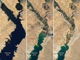
After 23 years of drought and increasing demand for water, Lake mead keeps shrinking. Satellite photos show the stark difference between the way the reservoir looked in 2000—dark blue and sprawling—and what’s left now. Satellite photos show how much the Lake Powell reservoir shrank in just one year, from spring 2021 to spring 2022. Near Sacramento, satellite images show the change from 2021 to 2022 as fewer farms had access to water for irrigation.If you walk to the edge of Lake Mead, on the border between Nevada and Arizona, you can stand on a rocky shore that used to be more than 100 feet below water. After 23 years of drought and increasing demand for water, the lake keeps shrinking. Satellite photos show the stark difference between the way the reservoir looked in 2000—dark blue and sprawling—and what’s left now.
As the water level keeps dropping, the neighboring Hoover Dam, which provides electricity to 1.3 million people, can’t generate as much power. The water is currently at 1,042 feet (boosted slightly by recent monsoon rains, but still only at 27% capacity). If it drops to 950 feet, hydropower will stop working—and water will stop flowing from the Colorado River to millions of people in Arizona, California, and Mexico.
Upstream, another reservoir, Lake Powell, has fallen to 24% of its capacity. These satellite photos show how much the reservoir shrank in just one year, from spring 2021 to spring 2022.
In Utah, the Great Salt Lake now has a fourth of the water that it did in 1987, both because of climate change and because so much water is being diverted to farming and cities.
As the dry lakebed is exposed, there’s a risk of arsenic and other heavy metals in the soil getting into the air and blowing into Salt Lake City in poisonous dust storms. As the falling water level makes the water saltier, wildlife may die off, and millions of migratory birds that stop at the lake may lose a food source.
As the drought continues in California, farmers in the state’s Central Valley—who grow a quarter of the food in the U.S.—are facing increasing restrictions on water use. Near Sacramento, these satellite images show the change from 2021 to 2022 as fewer farms had access to water for irrigation.
Even before the impacts of climate change became obvious, the West was mismanaging its limited water. The Colorado River, for example, “is massively oversubscribed,” says Peter Gleick, cofounder and senior fellow at the nonprofit Pacific Institute. “The demand for water in the region simply is greater than the reliable supply. And we’ve known that for a long time.”
Scientists have also known for decades that climate change would make things much worse. As it gets hotter, snow is melting faster and sometimes turning to water vapor before it reaches rivers. Rainfall is becoming more variable. Lakes and reservoirs lose more water to evaporation. And the hotter weather increases demand for water on farms and lawns.
It’s critical to slow the rate of climate change, Gleick says. And the way we manage water also needs to change.
“We have not had a real conversation about reducing agricultural water use in the Colorado River,” he says. There are better ways to irrigate and arguably better crops to grow; in Southern California, Colorado River water is used to grow alfalfa shipped to China, Japan, and Saudi Arabia. (Foreign companies have bought more than a quarter of a million acres of farmland in the Southwest in the last 20 years.)
Urban water use can also change. In California and other Western states, as much as half of the water used in cities is used to keep lawns green.
Governments are taking some steps—Los Angeles, for example, is planning new infrastructure to recycle water while restricting lawn watering. But cities, states, and the federal government still aren’t doing enough to meet the scale of the challenge, according to Gleick.
Western states just missed a deadline to make a water conservation plan for the Colorado River, and the federal government, which allocates the water, doesn’t seem to have a clear plan, either. Society also could have acted much sooner.
“We’ve known for literally decades that climate change is going to affect water availability in the Colorado [River] and in the Western U.S. in general,” Gleick says. “And we’ve wasted that time. We’ve ignored those warnings. Now we’re seeing the consequences of that.”
![July 6, 2000 [Image: NASA Earth Observatory]](https://images.fastcompany.net/image/upload/w_937,c_limit,f_auto,q_auto,fl_lossy/w_596,c_limit,q_auto:best,f_auto/wp-cms/uploads/2022/08/i-1c-90780839-these-stark-before-and-after-satellite-photos-show-the-western-megadrought-from-space.webp)
![Lake Powell, Utah, 2021 [Photo: courtesy Planet]](https://images.fastcompany.net/image/upload/w_937,c_limit,f_auto,q_auto,fl_lossy/w_596,c_limit,q_auto:best,f_auto/wp-cms/uploads/2022/08/01-90780839-these-stark-before-and-after-satellite-photos-show-the-western-megadrought-from-space.webp)
![The Great Salt Lake, 1985 [Image: ©USGS/contains modified Copernicus Sentinel data (2022), processed by ESA]](https://images.fastcompany.net/image/upload/w_937,c_limit,f_auto,q_auto,fl_lossy/w_596,c_limit,q_auto:best,f_auto/wp-cms/uploads/2022/08/i-2a-90780839-these-stark-before-and-after-satellite-photos-show-the-western-megadrought-from-space.webp)
![Sacramento River Valley, California, 2021 [Photo: courtesy Planet]](https://images.fastcompany.net/image/upload/w_937,c_limit,f_auto,q_auto,fl_lossy/w_596,c_limit,q_auto:best,f_auto/wp-cms/uploads/2022/08/05-90780839-these-stark-before-and-after-satellite-photos-show-the-western-megadrought-from-space.webp)


0 comments:
Post a Comment